
On behalf of the entire Certainty 3D team, I can tell you how thrilled we are to issue our first E-Newsletter, "The TopoDOT® Times". Every month, we'll share our insights into the LiDAR industry. In our Feature Spotlight, we'll focus on the latest TopoDOT® developments and let you know why they could be very important to you. In each issue, a TopoDOT® customer will share a unique experience applying LiDAR technology. Then we'll tie it all up with a brief Tech Tip with the latest in tools and workflows. The TopoDOT® Times will become an important part of your TopoDOT® experience, keeping you informed and on the cutting edge of performance.
Ted Knaak
President, Certainty 3D
Call Us for a Quotation
Get a Quote
Product Spotlight
In this inaugural edition of the TopoDOT® Times, we step back and take a look at how TopoDOT® fits into to your process workflow. Visitors to our website will note our mantra of "Integrating LiDAR Data Across Operations". TopoDOT® accomplishes this integration by providing the tools to execute the three basic components of your workflow: Manage, Assess and Extract. TopoDOT® management tools will organize your LiDAR data quickly and efficiently for optimal storage and sharing. Use the integrated feature, TopoCloud™, to store and share data on a private server, the Amazon® Cloud, or Bentley's Projectwise®. Assess data quality using TopoDOT®'s comprehensive tool suite and the workflows so well documented in TechNote #1021. Finally, extract high quality 3D topographies and CAD models to "feed" your customer's design, engineering and construction applications. TopoDOT® is more than a point cloud processing tool. TopoDOT® is a comprehensive solution to integrating LiDAR data across your operations.
Customer Focus Story - TopoCloud™ Streamlines Data Sharing
Paul DiGiacobbe, Director of Geospatial Services at Maser Consulting
Maser Consulting is a privately owned, multi-disciplined, engineering firm with a unique balance of public and private sector experience. Headquartered in Red Bank, NJ, the firm has consistently been recognized nationally by Engineering News Record as one of its Top 500 Design Firms, employing over 500 professionals nationally with 17 offices along the east coast and one in New Mexico.
Over the past few years Maser has been investing in building a team of 3D static and mobile laser scanning experts that are now part of a new group called Maser Geospatial.. The team is led by Paul DiGiacobbe who is the Director. Paul has worked in the transportation consulting field for the past 29 years and has been involved with Certainty 3D and TopoDOT since the beginning.
Paul commented, "They key difference when you compare TopoDOT to other LiDAR data processing tools is derived from its roots. When Ted started the company he understood that his customers wanted to use the 3D data to support their CAD workflows. Since the majority of transportation agencies are Microstation users he chose that as his platform. That is what makes his software so productive, regardless of whether the data is from a mobile or static scanner TopoDot delivers design control objects in Microstation format."
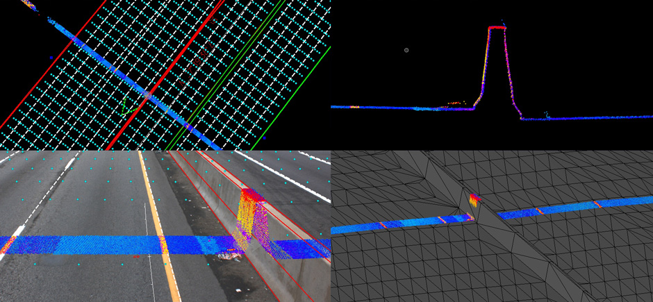
One recent transit project in Philadelphia highlights the ability of TopoDOT to meet demanding schedules. The project consisted of seven miles of dual rail commuter track and overhead power lines. Access to the rail was limited to just two hours in the early morning when trains were not running. The first month of the project was spent establishing control. Then using a Riegl VMX 450 mobile scanning system mounted on a high rail vehicle the data was collected in one four hour window. At no time during the project was a revenue generating train affected.
The data collected revealed a very complicated layout. TopoDOT was used to efficiently determine the top of rail, the location of the rails and the 3D geometry of the overhead powerline catenaries. "What made the project such a success was the use of TopoCloud," Paul noted. "We were able to have our processing teams in four different locations work simultaneously on the project."
TopoCloud provides an interface to point cloud data stored in the cloud allowing multiple teams access to one secure central database. The increase in productivity can be substantial. Stay tuned for more on TopoCloud in future articles.
Written by Gene Roe
Tech Tip: Wiki has the answers
C3D University registered users have access to TopoDOT®'s WikiManual. Since it is an online manual, it is constantly being updated and the wiki style is familiar to most people. Accessing a tool in the manual is fast an easy by pressing F1 while the tool is active. Browsing for a tool in question is a breeze since the WikiManual is laid out similar to the TopoDOT® menu. Each tool features a description of the buttons and settings, a tutorial on how to use it and a discussion area where users make relevant comments. Also the tools' breadcrumbs help in identifying how the tools relate to one another. Check out TopoDOT®'s WikiManual here.
Exhibit Schedule
- Transportation Data Symposium in Champions Gate, FL on August 18 - 20
- InterGeo in Stuttgart, Germany on September 12 - 19
- AASHTO in Chicago, IL on September 24 - 28
- APC/PennDOT in Hershey, PA on November 18 - 20
- MDSPE in Baltimore, MD on October 7 - 10
- For more information take a look at our calendar of events


